Major Highlights
Hands-on Training on – QGIS, SAGA GIS, Google Earth Pro, GIS, GPS, Work with various spatial models
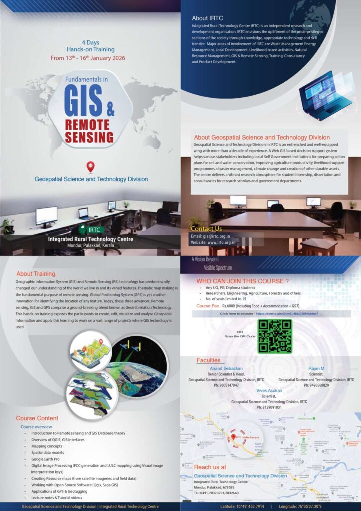
*Training Date : 13th to 16th January, 2026*
*Venue: Geospatial Science and Technology Division, IRTC Jubilee Campus (New campus), Kozhikode – Palakkad Hwy, Opposite of Sinayi Retreat Centre, Mundur-I, Palakkad, Kerala, 678592.
A maximum of 15 seats is allotted for training. Please enroll before the seats are filled
Registration Link https://docs.google.com/forms/d/e/1FAIpQLSepXMYd2YkvTCNgdhBKwEP7Clv91QETlmLxxA7miCi2kE4P-w/viewform usp=sharing&ouid=102463525918993177062
E-Brochure Link: https://drive.google.com/file/d/1hPVT5pXTNaZyiXf7Fz2yPRqPDvNKt_IQ/view?usp=sharing
Registration fee: ₹6000 per person (including Food, Accommodation & GST)
Program Highlights:
1 Introduction to Remote Sensing and GIS Database: Understand the basics of GIS, its applications, and how it revolutionizes spatial analysis.
2. Data Collection and Management: Learn effective methods of collecting, storing, and managing geospatial data to ensure data integrity and accessibility.
3. Spatial Analysis Techniques: Spatial data models, Digital Image Processing (FCC generation and LULC mapping using Visual Image Interpretation keys).
4. Cartography and Mapping concepts: Gain expertise in creating visually appealing maps and cartographic presentations that effectively communicate your findings.
5. GIS Software Training: Overview of QGIS, GIS interfaces, Working with Open-Source Software (QGIS, Saga GIS). Creating Resource maps (from satellite imagery and field data)
6. Real-World Case Studies: Explore practical examples and case studies where GIS has been used to solve complex spatial problems in different domains.
7. Google Earth Pro, and Applications of GPS & Geotagging
Training Benefits:
• Acquire fundamental knowledge and practical skills in GIS.
• Enhance your problem-solving abilities by utilizing spatial analysis techniques.
• Strengthen your resume with valuable GIS skills sought by employers in various industries.
• Network with professionals and GIS enthusiasts in the field.
• Obtain a certificate of completion at the end of the training.
Note: Certificates will be issued to all participants who complete the four-day training.
Apply soon to explore the opportunity.
For any Inquiries, contact:
Anand Sebastian (Head and Senior Scientist)
Geospatial Science and Technology Division, IRTC
Mob. : 9605147047
Mr. Rajan M (Scientist)
Geospatial Science and Technology Division, IRTC
:9496568829
Mr. Vivek Asokan (Scientist)
Geospatial Science and Technology Division, IRTC
:8129091831
Ph.: 0491-2832663
Mail to: [email protected]
Location details: https://goo.gl/maps/NfayhfH7fHveLc5T8
Explore the opportunity, Learn and grow with us ….
–Please share with your friends—
Thanks and Regards,
Geospatial Science and Technology Division
Integrated Rural Technology Centre (IRTC)
Mundur, Palakkad, Kerala
Email: [email protected]